Crags, Take Two

Following this, we packed up our gear and headed to Legend lake. We knew it was close, consulting the map and making a plan of attack, we headed out on our second day of hiking. We eventually spooked, then followed a retarded Spruce grouse the size of a basketball and got our first view of Legend lake. Legend is definitely correct. It was a gem in the rocks, with large fish cruising to boot! We spent a bit of time there, cooling our feet and getting ready for the assault on the ridge. (I had a terrible thought and figured we could stay at Legend, rig a line, kill a grouse and have a delightful camp and gourmet dinner...with an easy ridge-hike out to the truck the next day. Good thing our epic had JUST started beginning.) Rachel and I both wanted more country, so decided to push on.
Perfect. (This eased Matt's soul)
Alright, so we TORE ourselves from Legend and headed up the hill. Finding the easiest route wasn't really a problem, it was the gentlest route we could find and headed in the general direction we needed to go. Plus, there was a peak there that I HAD to get up, so that won hands down. It took a little time because it was very steep. But, we made it, dropped the packs below the precipice that was the top of the hill, and ascended to find many many flying ants and ladybugs. (Ladybugs...and obviously flying ants...make nests on tops of mountains, a little snack for grizzly bears.)
Da' Peak
No bugs at the swampy pond, but bugs on top of the hill? What gives?
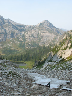
We got off the top of that hill quick, again burdened ourselves with 40 lb packs and eased to the saddle we needed to get to in order to get down to Three Links. Looking over this saddle was a sight! Imagine looking past your toes at a puddle. That's what we were up against. So down we went. I'm not sure of the percent/degree of the slope, but it was an easy double-black diamond so what a 90 degree is a cliff...is a double-black 45 degrees or more? Alright, well, it was 1200 feet down in less than a mile.
This ain't steep! (Note the sarcasm)
I managed to slip once on the grass and slide for a couple of feet before getting my footing. This grassy hill soon turned into an even steeper section, followed by rocks, a small snowy section, bigger rocks, then a punch through essentially the creek (flowing from the snow) down the hill. Imagine wet rocks, moist-site plants, and water....hiding obstacles, holes, etc. Not much fun, but what a relief to reach the bottom! I believe it took us 2 hours to reach the bottom of this hill, just an indication of the level of difficulty. All the while, as Rachel put it, "I just imagine the pikas are cheering me on."
Krista near the point where I slid.
Eek! Pikas are cute! (Again, thank you Google Images.)
Pikas are fun little high mountain, rock-dwelling creatures. The say "eek!" at everything. I am convinced they are scared, paranoid critters that wake up in the morning in a state of shock and just keep that through the day. Eek! It's light out! Eek! Bipeds! Eek! Grass! We developed the term "trail drunk" because we began replying to the pikas (in their own language) and laughing incessantly at every little "EEK."
We made the lake at 1800 and found our final resting place (if we shall call it that for the time being) at probably 1900. Setting up camp and eating dinner, Krista called it good and turned in. Again, the meteor shower was impressive. Plus, who else can say they watched the Big Dipper set in the Selway-Bitterrroot Wilderness?
There was no problem falling asleep that night. I thought I could see the trail across the creek to the north, so was confident that it would just be trail hiking on the way out. We had to get to Jesse Pass and then drop over to Cove Lakes. After that, it was a short uphill, then downhill to Canteen Creek...after that, it was a short jaunt to the truck! No worries. I went to bed very pleased, tired, and happy that we finally had a trail.
Hmmm, we'll see.
A word of warning: There are NO certainties in the Crags. Rely on the maps for topography, but leave it at that. Don't trust the size of the lakes, the trails, or the contours for that matter. It WILL be worse than you imagine it can be, which all makes a trip into an epic.
More later...


0 Comments:
Post a Comment
<< Home